Twitten Ditty
There
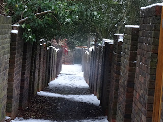
are 2 km of Public Rights of Way (PROW's) on the Cambridge road estate. These were entered on the
Definitive Map last year, after correspondence between myself, the borough Highways department and the Secretary of State. My application to have them recognised - with help from Sunflower Streets residents assoc. - was perhaps a pyrrhic victory, as the planning application to approve the regeneration of the estate will remove them through STOP orders.
But they won't be forgotten and those wishing for further discussion including information on Radburn Lines, can obtain 'A Little Book About Paths', available for purchase on Ebay.
One positive outcome has been the post of a Rights of Way Officer for Kingston and Sutton with the two boroughs contributing £25,000 each. This means the 'Rights of Way Improvement Plan,' 2009 might at last recieve attention. This is timely as there are many examples of PROW's no longer usable such as the dog -leg between Kingston Vale and Robin Hood Lane, where bamboo and fly-tipping from residents gardens fills the route. The problem of smashed finger posts also requires attention.
If you want to track your local paths, the Ordinance Survey map would be the first port of call but these can be ~ five years out of date or more although there is probably an electronic 'master' version that is updated whenever the OS is notified of changes. Some paths on maps are shown as an off-line route which is the one walked rather than the definitive line.
Find My Street - is very useful to identify the PROW's and help identify private tracks.
Google Earth - is useful as the aerial view can reveal hidden features confirmed by switching to Streetview.
Historic maps -Old maps.org and the National Library of Scotland
By using old maps and the OS map, it is possible to track the history of any path and identify when it 'fell off the map'. If the path appears on the early maps but not on the later ones, it suggests it never made it onto the Definitive Map and then were not included on the OS map.
Information courtesy of Ramblers 'Don't lose your way campaign which has so far found nearly 50,000 PROW miles missing from the Definitive Map of England and Wales and its now racing to save these by 2026. There is also 'Rights of Way: Restoring the Record', Bucks and Wadey as well as the classroom of 'Bitter Experience'.Although this was sweetened by the compensation received from the Local Authority after my journey walking through the corridors of bureaucratic dysfunction described below in the Ditty.
Read with beer


Comments
Post a Comment
Please share your thoughts